
LiDAR Mapping for Documenting Existing Site Features
A property is more than its boundary lines. It includes buildings, walls, slopes, driveways, and structures that were added over time. If nobody has a clear record of these features, planning a new project becomes guesswork.
LiDAR mapping solves this problem. It uses laser scanning to create a detailed, measurable record of everything on a site. This includes the ground, the structures, and the features in between.
For property owners, developers, and buyers, this kind of record can prevent costly surprises. It shows what is actually there, not just what old plans say should be there.
Creating a Measurable Site Record With LiDAR Mapping
LiDAR mapping uses laser pulses to scan a site from multiple points. Each pulse bounces off a surface and returns to the scanner. The scanner uses this to calculate exact distances and positions.
The result is called a point cloud. It is made up of thousands or millions of data points. Together, these points create a detailed, three-dimensional picture of the property.
This matters because a measurable record gives everyone the same starting point. Engineers, architects, and contractors can all work from the same accurate data instead of guessing from old drawings or rough field notes.
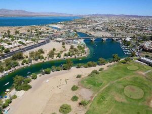
In a growing area, where lakefront lots and desert terrain both bring their own challenges, having a true site record helps avoid design mistakes before construction starts.
Why Older Records Often Fall Short
Many properties were built or modified years ago. Old surveys or hand sketches may not match current conditions. Additions, fences, and landscaping can all change a site without any new documentation. LiDAR mapping captures the site as it exists right now.
Capturing Vertical and Hard-to-Reach Site Features
Some site features are hard to measure with regular tools. Rooflines, retaining walls, and steep slopes all fall into this category. Desert lots with rock outcroppings or wash areas add another layer of difficulty.
LiDAR mapping handles these features well because it scans from multiple angles and heights. This captures details that ground-based measurements alone might miss.
Common hard-to-reach features include:
- Roof edges and overhangs
- Tall retaining walls near sloped lots
- Steep or rocky terrain
- Areas behind fences or dense landscaping
This matters for construction planning. If a contractor does not know the true height of a wall or the true slope of a hillside, the project can run into problems once work begins. Confirm with your surveyor whether your site has features that need this level of detail.
Showing Spatial Relationships Between Existing Improvements
A site is not just a list of separate features. Buildings, walls, driveways, and utilities all relate to each other in space. Knowing these relationships helps prevent conflicts during design and construction.
LiDAR mapping shows exactly how these features sit next to one another. This includes distances between structures, clearances along property lines, and the relationship between grade changes and buildings.
This is especially useful for properties near the water, where docks, seawalls, and setbacks all need to line up correctly. It also helps on inland lots where additions or outbuildings may have been built without careful measurement.
A few examples of spatial questions LiDAR mapping can help answer:
- How close is this structure to the property line?
- Does this addition meet setback requirements?
- How does the slope affect drainage between buildings?
These answers help designers avoid rework and help owners avoid permit delays.
Separating LiDAR Site Data From Boundary Determinations
LiDAR mapping is powerful, but it does not replace a legal boundary survey. This is an important distinction that gets confused often.
LiDAR data shows physical conditions. It records what is visibly on the ground, like structures, walls, and terrain. It does not, by itself, establish where a legal property line sits.
A licensed surveyor determines boundaries using recorded deeds, plats, monuments, and survey control points. Once boundaries are established, LiDAR data can be layered on top to show how existing features relate to those lines.
This separation matters because assuming a fence or wall marks the true boundary can lead to real problems. Boundary rules and required documentation can vary by property type, lender, title company, county, or project scope. If your project depends on confirmed boundaries, ask your surveyor early what type of survey you actually need.
Updating Site Documentation Before Property Changes
Site conditions change over time. Additions get built. Landscaping shifts. Grading changes after storms or renovations. If your site documentation is outdated, any new project built from it starts on shaky ground.
Updating your site record with LiDAR mapping before a renovation, sale, or new construction project gives everyone accurate current data to work from. This is especially useful before:
- Starting a renovation or addition
- Listing a commercial or residential property for sale
- Applying for new permits
- Beginning due diligence on a purchase
In Lake Havasu, where both residential growth and commercial development continue along the waterfront and surrounding areas, updated site data helps buyers, lenders, and title companies move through a transaction with fewer unknowns.
If your timeline depends on permitting, financing, or a closing date, confirm early how current your site documentation needs to be. Waiting until later in the process can create delays that are hard to recover from.