
Land Survey Cost and Why the Price Is Never the Same
 If you have ever asked a surveyor for a quote and walked away more confused than when you started, you are not alone. Land survey cost can range from a few hundred dollars to several thousand, and the difference is not random. It comes down to a handful of real factors that change from one property to the next.
What Does a Land Survey Cost on Average?
Nationally, most homeowners pay between $400 and $1,000 for a standard residential boundary survey. In Arizona, that range shifts slightly depending on the county and terrain. In Mohave County, which includes Lake Havasu City, you can expect to pay anywhere from $500 to $2,500 for a typical residential lot. More complex properties can push past $5,000.
These are not arbitrary numbers. They reflect real differences in the time and equipment a surveyor needs to get the job done accurately.
The Six Things That Change the Price
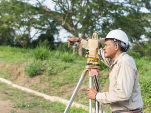
Property size
Larger lots take longer to survey. A quarter-acre residential lot in a planned subdivision is a very different job from a five-acre parcel on the edge of town. More ground means more time in the field, more measurements, and more work back at the office.
Terrain and ground conditions
This one matters a lot in Lake Havasu. The desert terrain around Mohave County is rocky, uneven, and spread across varied elevations. That kind of ground slows surveyors down. Rocky soil makes it harder to locate or set property markers. According to field practice across the region, difficult terrain can add 30 to 50 percent to the time required compared to a flat suburban lot. That extra time shows up in the bill.
Type of survey needed
Not every survey is the same. A simple boundary survey to confirm your property corners costs less than an ALTA/NSPS survey required for a commercial real estate transaction. A topographic survey that maps elevation changes across a lot costs more than a mortgage survey that only verifies basic boundaries. Knowing which survey type you actually need before calling for a quote will save you confusion.
Age and quality of existing records
If a property has clear, recent records, a surveyor can get started faster. Older properties, irregular lots, or parcels with gaps in the chain of title take more research. Surveyors often need to dig through county records, old deeds, and historical plat maps before they ever set foot on the land. That research time is part of the cost.
How quickly you need it done
Standard turnaround in the Lake Havasu area runs about one to two weeks for a residential survey. If you need results faster for a closing deadline or a construction start date, rush fees apply. Prioritizing your job means pushing others back, and surveyors charge accordingly.
Surveyor experience and licensing
In Arizona, all practicing land surveyors must hold a Professional Land Surveyor (PLS) license issued by the Arizona State Board of Technical Registration. Practicing without one is illegal. More experienced surveyors sometimes charge higher rates, but they also tend to complete complex jobs more efficiently and with fewer errors. A lower quote from someone less qualified can cost far more if their work is ever challenged.
Waterfront and Irregular Lots Cost More
Lake Havasu City sits along the Colorado River, and waterfront properties come with their own survey challenges. Lots near the water often have irregular boundaries, shared access questions, and flood zone considerations that standard inland parcels do not. These details require extra time and precision, and they push survey costs toward the higher end of the range.
Irregular or oddly shaped lots also take longer to survey regardless of their location. A standard rectangular lot in a subdivision is straightforward. A wedge-shaped parcel with multiple bearings and a shared boundary with a neighbor who disputes the line is a different job entirely.
Why the Cheapest Quote Is Often the Riskiest Choice
It is tempting to go with the lowest number, especially when budgets are tight. The problem is that a survey error does not stay buried for long. Boundary mistakes surface during fence construction, permit applications, property sales, and title insurance reviews.
According to the American Land Title Association, roughly one in three real estate transactions involves a title or boundary issue that needs resolving before the deal can close. A survey done correctly the first time prevents that problem. One done poorly can lead to legal disputes, permit rejections, and costs that far exceed what you saved on the original quote.
That is not a reason to overpay. It is a reason to verify that whoever you hire is licensed, insured, and has experience with the type of property you own.