
How Do I Find My Property Line Without a Headache
 At some point, almost every property owner asks the same question. Where does my land end and my neighbor’s begin? Maybe you want to put up a fence. Maybe a neighbor planted something too close to the edge. Maybe you just want to know.
Finding your property line is not always simple. But there are real steps you can take. Knowing where to start saves a lot of time.
Start With Your Deed
Your deed is the legal document that describes your property. It contains a written description of your boundaries. It uses directions and distances to define the shape of your lot.
For older properties in Mohave County, these descriptions can be hard to follow. They may reference landmarks that no longer exist. They may also use older surveying language. But the deed is still the first place to look. You can get a copy from the Mohave County Recorder’s office or find it online through Arizona’s land records system.
Reading a deed description takes practice. Directions are written as compass bearings, like North 45 degrees East. Distances are usually in feet. Together, they trace the outline of your lot from one corner to the next.
Check the Recorded Plat
If the deed references a recorded plat, that is even more useful. A plat is a drawn map of your subdivision filed with the county when the land was divided. It shows a lot of lines, dimensions, and how your parcel relates to those around it.
You can find plat maps through the Mohave County Assessor’s website or the Recorder’s office. A plat gives you a clear picture of your lot. It is much easier to read than a written boundary description.
One thing to keep in mind: a plat shows recorded dimensions. It does not confirm where those lines fall on the ground. On older lots, the numbers on paper and the physical markers in your yard may not line up.
Use the County GIS Portal
Many counties now offer online GIS portals. GIS stands for Geographic Information System. It is a digital map tool that lets you look up property boundaries by address or parcel number.
Mohave County has a public GIS portal where you can view parcel boundaries over aerial imagery. This is a good starting point. You can see the general shape of your lot and how it sits next to your neighbors.
But GIS maps have a key limitation. The lines shown are based on recorded documents, not field measurements. They can be off by several feet. Courts and permit offices do not accept GIS lines as proof of a boundary. They are a reference, not a legal answer.
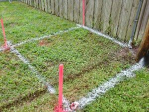
Look for Physical Markers on Your Lot
When a property is surveyed, the surveyor sets physical markers at the corners. These are usually iron rods or pipes driven into the ground. Many have a metal cap on top showing the surveyor’s license number.
On older properties, these markers can be hard to find. They may be buried under soil or grass. In the Lake Havasu area, desert landscaping, caliche soil, and rocky ground make them harder to spot without equipment.
To look for markers yourself, start at the corners shown on your plat map. Probe the ground with a metal rod. A handheld metal detector also works well. Look for a small cap or the top of an iron pin at or just below the surface.
Finding a marker does not mean it is in the right place. Markers can be moved by accident or on purpose. A disturbed marker is not reliable. Only a licensed surveyor can confirm whether a marker is valid and correctly placed.
What About GPS Apps?
Some homeowners use GPS apps or satellite tools to find their property lines. These apps show parcel boundaries on a map using your phone’s location. They are free and easy to use, but they share the same limitation as GIS portals.
The lines shown come from recorded data, not physical measurements. Accuracy varies widely. In some cases, the displayed line can be off by ten feet or more. That kind of error matters when you are deciding where to build a fence or pour a slab.
GPS apps are fine for a rough idea of where your lot sits. They are not reliable for construction, legal decisions, or disputes.
When Your Research Is Not Enough
If you work through all these steps and still are not sure where your line is, that is a normal outcome. It does not mean something went wrong. It means your property needs a field survey to confirm the boundary with legal accuracy.
This matters most in a few situations. If you plan to build anything near the edge of your lot, you need a confirmed boundary, not an estimate. If a neighbor is disputing the line, a licensed surveyor’s work is what carries weight. If you are selling or refinancing, a lender or title company may require a current survey.
The research you did using deeds, plats, and GIS is still useful. It gives a surveyor a head start. It can also cut down the time they spend on records work before visiting your property.